


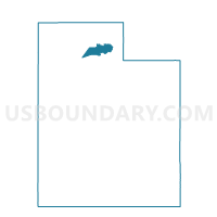
Lake 1 Voting District, Weber County, Utah
About
Outline

Summary
| Unique Area Identifier | 680549 |
| Name | Lake 1 Voting District |
| County | Weber County |
| State | Utah |
| Area (square miles) | 79.14 |
| Land Area (square miles) | 5.25 |
| Water Area (square miles) | 73.88 |
| % of Land Area | 6.64 |
| % of Water Area | 93.36 |
| Latitude of the Internal Point | 41.16449580 |
| Longtitude of the Internal Point | -112.34542420 |
Maps


Graphs
Select a template below for downloading or customizing gragh for Lake 1 Voting District, Weber County, Utah


Neighbors
Neighoring Voting District (by Name) Neighboring Voting District on the Map
- Great Salt Lake Voting District, Box Elder County, UT
- Grouse Creek Voting District, Box Elder County, UT
- Hooper 1 Voting District, Weber County, UT
- Hooper 2 Voting District, Weber County, UT
- Lake Point 01 Voting District, Tooele County, UT
- Warren 1 Voting District, Weber County, UT
- z Unassigned West Voting District, Davis County, UT
Top 10 Neighboring County Subdivision (by Population) Neighboring County Subdivision on the Map
- Ogden CCD, Weber County, UT (208,109)
- North Davis CCD, Davis County, UT (197,425)
- Tooele-Grantsville CCD, Tooele County, UT (54,800)
- Northwest Weber CCD, Weber County, UT (16,523)
- Howell-Snowville CCD, Box Elder County, UT (2,769)
- West Box Elder CCD, Box Elder County, UT (383)
Top 10 Neighboring Place (by Population) Neighboring Place on the Map
Top 10 Neighboring Unified School District (by Population) Neighboring Unified School District on the Map
- Davis School District, UT (306,479)
- Weber School District, UT (148,422)
- Tooele School District, UT (58,218)
- Box Elder School District, UT (49,975)
Top 10 Neighboring State Legislative District Lower Chamber (by Population) Neighboring State Legislative District Lower Chamber on the Map
- State House District 13, UT (50,040)
- State House District 6, UT (46,570)
- State House District 1, UT (34,122)
Top 10 Neighboring State Legislative District Upper Chamber (by Population) Neighboring State Legislative District Upper Chamber on the Map
- State Senate District 21, UT (112,079)
- State Senate District 17, UT (102,922)
- State Senate District 20, UT (97,406)
Top 10 Neighboring 111th Congressional District (by Population) Neighboring 111th Congressional District on the Map
Top 10 Neighboring Census Tract (by Population) Neighboring Census Tract on the Map
- Census Tract 1254.03, Davis County, UT (11,439)
- Census Tract 1254.01, Davis County, UT (11,309)
- Census Tract 2105.04, Weber County, UT (8,708)
- Census Tract 2104.03, Weber County, UT (7,621)
- Census Tract 9601, Box Elder County, UT (3,152)
- Census Tract 9800, Tooele County, UT (0)